


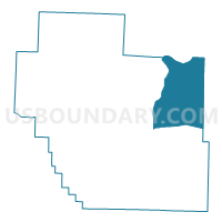
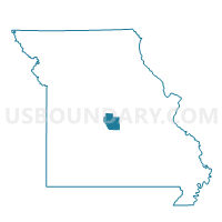
St. Elizabeth Voting District, Miller County, Missouri
About
Outline

Summary
| Unique Area Identifier | 609121 |
| Name | St. Elizabeth Voting District |
| County | Miller County |
| State | Missouri |
| Area (square miles) | 58.92 |
| Land Area (square miles) | 58.48 |
| Water Area (square miles) | 0.44 |
| % of Land Area | 99.26 |
| % of Water Area | 0.74 |
| Latitude of the Internal Point | 38.26842850 |
| Longtitude of the Internal Point | -92.24565650 |
Maps

Graphs
Select a template below for downloading or customizing gragh for St. Elizabeth Voting District, Miller County, Missouri


Neighbors
Neighoring Voting District (by Name) Neighboring Voting District on the Map
- Eugene Voting District, Cole County, MO
- Marys Home Voting District, Miller County, MO
- Mason Ridge Voting District, Maries County, MO
- Meta Voting District, Osage County, MO
- Osage Voting District, Miller County, MO
- St. Anthony Voting District, Miller County, MO
- St. Thomas Voting District, Cole County, MO
Top 10 Neighboring County Subdivision (by Population) Neighboring County Subdivision on the Map
- Osage township, Cole County, MO (4,179)
- Clark township, Cole County, MO (3,707)
- Osage township, Miller County, MO (1,585)
- Jackson township, Osage County, MO (1,376)
- Jim Henry township, Miller County, MO (1,051)
- Boone township, Maries County, MO (660)
Top 10 Neighboring Place (by Population) Neighboring Place on the Map
Top 10 Neighboring Unified School District (by Population) Neighboring Unified School District on the Map
- Osage County R-III School District, MO (6,495)
- Cole County R-II School District, MO (6,068)
- Cole County R-V School District, MO (4,962)
- Maries County R-I School District, MO (4,026)
- Iberia R-V School District, MO (3,972)
- Miller County R-III School District, MO (1,414)
- St. Elizabeth R-IV School District, MO (1,263)
Top 10 Neighboring State Legislative District Lower Chamber (by Population) Neighboring State Legislative District Lower Chamber on the Map
- State House District 115, MO (37,008)
- State House District 113, MO (35,216)
- State House District 112, MO (34,350)
Top 10 Neighboring State Legislative District Upper Chamber (by Population) Neighboring State Legislative District Upper Chamber on the Map
Top 10 Neighboring 111th Congressional District (by Population) Neighboring 111th Congressional District on the Map
Top 10 Neighboring Census Tract (by Population) Neighboring Census Tract on the Map
- Census Tract 9625, Miller County, MO (5,656)
- Census Tract 202, Cole County, MO (4,158)
- Census Tract 203, Cole County, MO (3,538)
- Census Tract 4903, Osage County, MO (3,536)
- Census Tract 8802.98, Maries County, MO (2,732)
Top 10 Neighboring 5-Digit ZIP Code Tabulation Area (by Population) Neighboring 5-Digit ZIP Code Tabulation Area on the Map
- 65459, MO (8,233)
- 65486, MO (3,423)
- 65032, MO (1,792)
- 65040, MO (1,208)
- 65082, MO (1,127)
- 65058, MO (1,017)
- 65076, MO (829)
- 65075, MO (784)